
Hello Everyone! I’m back with more pictures of our California Central Coast trip. These pictures take us to Monterey, Big Sur and back to Santa Cruz. We had lots of fun exploring even in the rain. Fortunately, we did have a little sun most days.

Our first stop on the fourth day was to the Monterey Aquarium, built in some of the old cannery buildings. My daughter is studying Marine Biology and it gave her a chance to show off some of her knowledge of the marine life!

Of course she had to get some artsy photographs.

It was probably one of the best aquariums I’ve been in. It rained all morning, so staying inside was a good thing.

We captured this little guy outside the aquarium. The Sea Otters were fun to watch all along the coast. We also saw Sea Lions and Seals, too.

We enjoyed driving around the Pacific Grove point and watching the waves crash on the rocks. We were on our way to do the 17-Mile Drive to Pebble Beach and my husband wanted to start at the very beginning of the road. We found it in Pacific Grove and drove along it for a few miles until entering the Drive at Pebble Beach.
17-Mile Drive is a scenic drive through the Pebble Beach Golf Resorts and along the shore line. It was beautiful. We were given a map at the gate, (a $10 fee for non-residents) of all the points of interest along the drive.


These were taken on the beach at Fanshell Overlook. I couldn’t get enough of the waves and the rocks.

This is overlooking the same beach area. In the background, you can see the golf course and houses at Spyglass Hill. I could have this view everyday!
After many interesting points and the same type of scenery, we made our way to

The Pebble Beach Golf Club House and Shops! We are pretty big fans of golf and the Pebble Beach Pro-Am is a favorite to watch each year.

This is the 18th hole on Stillwater Cove and you can just make out Carmel by-the-Sea in the back. It was a beautiful course. It will be fun watching the golf tournament next year after being here. We finished our day with a drive through Carmel then it was time to head back after another full day.
Our fifth day was supposed to be our best weather day, so we did the Big Sur drive on Highway 1. We got an early start and headed south. The drive was spectacular, even in the rain and mist. Fortunately, it wasn’t foggy. Our plan was to drive to our furthest point, then work our way back north when the weather would hopefully clear. We did stop at McWay waterfalls on the way down (and back), but the rangers were just closing part of the trail to overlook the falls because of a small rock slide.
We continued all the way down to Limekiln State Park. Highway 1 was closed just past this point because of a mud slide. It did rain on us pretty hard when we first arrived, so we had lunch in the car and waited, then headed out for our hike in the rain anyway.
 The park had many things to offer. One was a waterfall that we unfortunately couldn’t get to because you had to wade the creek. Because of the rain, it was a little high. We did hike through a redwood grove, though.
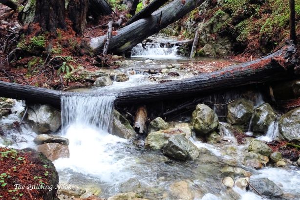
We did see a few smaller falls along Limekiln Creek on our way to the furnaces.

These are three of the four furnaces where lime was produced from the limestone rocks.

The park went out to the ocean, too. This is Limekiln Creek flowing into the ocean. I’m used to seeing big rivers become part of the ocean, not little creeks.

This was a beautiful area and there were camp sites almost to the beach. After this, we headed north again and the weather started to clear so it turned out to be a beautiful afternoon.
My daughter had a list of things she wanted to see, so we made our stops along the way.

We stopped at McWay Falls again and walked down the trail as far as we could for more pictures. This picture was taken from a car turnout a little above the trail. The falls were in Julia Pfeiffer Burns State Park. The waterfalls are 80 feet high and we were way above them.
 This picture is overlooking the cove where the falls are located.

This is one of my favorite pictures. I think it was taken from the turnout we stopped at to look at the waterfalls.
One of our stops included Pfeiffer Beach. You had to know it was there to get to it. There was no signage on Highway 1 pointing you in the right direction.

It was another beautiful area, but part of the attraction was the purple sand.

One of the things my daughter wanted to see was the Bixby Bridge. We looked for it all day as we passed over different bridges. As it turned out, it was the first one we went over that morning and didn’t know it. It is much easier seeing it driving north rather than south and it was raining when we passed it in the morning.

This is another favorite photo taken from the bridge area. You can see how the mountains come right down to the ocean. That’s Highway 1 winding it’s way south in the middle of the green field, too. Somewhere between the falls and here, we started seeing blowhole spouts of water coming from gray whales migrating offshore. We stopped at an area to watch several of them. You could just catch glances of them. Unfortunately, they don’t come out of the water like Humpbacks or Orcas do (according to my daughter).

We finished the day with a stop back at Carmel Beach. My husband wanted to see Pebble Beach Golf Course from the beach.
For our final day, we had a decision to make. Our plans were to go to Pinnacles National Monument. It looked like it was more of a hiking park and not a driving park. We were tired and with all the rain, we didn’t know how it would be. So, we decided to go back to Santa Cruz and have lunch and shop in Capitola.

One the places we missed on the drive from San Francisco was Shark Fin Beach. This was on my daughter’s list, so we drove a little past Santa Cruz to see it. 
This was another beautiful area. Interesting though, a lot of the rocks in the water looked like they had been sheared off. I don’t know if an earthquake did that many years ago or not.
We drove back through Santa Cruz and went to the boardwalk area. My daughter wanted to get some pictures of it and the beach and it was a pretty morning. As we were standing on the boardwalk overlooking the beach, my husband saw a fin in the water.

This was as much as I could get of the gray whale that was about 30 yards off the beach. It was obviously feeding and we thought there might be two, a mother and baby. There were not many people on the beach, but a local man who was fishing told us he had never seen one come in this close to the beach before. We watched it for about 15 minutes before it moved on. That was a nice end to our trip. We had lunch and shopped in the rain, then it was time to head back to the condo and pack up for our trip home.
I’m going to leave you with a couple of pictures my husband took a week after our trip while he was flying between L.A. and Seattle.
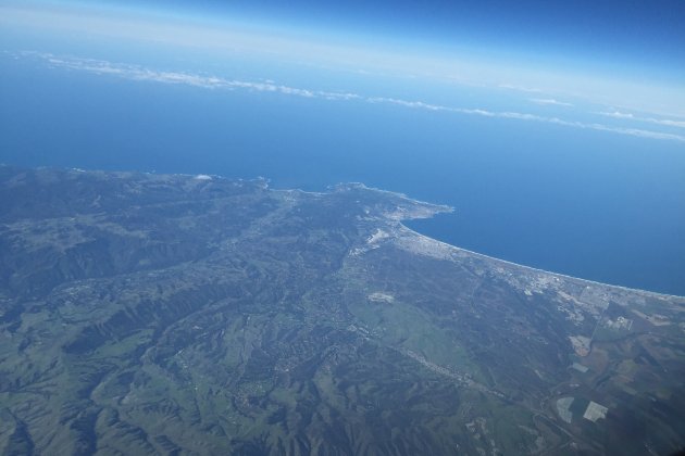
This is Monterey (the right side of the point), Pebble Beach, Carmel and the beginning of Big Sur.

Our condo was located just north of the river entering the bay in the center left of the picture. Santa Cruz is at the top of the bay. Not bad pictures taken with his iphone6.
I hope you enjoyed my pictures. This part of California is absolutely spectacular. We might never have visited if it weren’t for my daughter’s friends in San Francisco! I’ll be back soon with some quilting updates.


Hey, he’s supposed to keep both hands on the wheel! Love these photos-makes me want to plan a trip to the west coast.
LikeLike